


Walking to the Sources
of the River Wye
Root Of The Rivers
Remote walks to the birthplace of the River Wye and other rivers of the Wye basin
Rising on the eastern slopes of Plynlimon (Pumlumon) in Mid Wales, the River Wye begins its journey in some of the most remote and quietly dramatic upland landscapes in Britain.
These walks follow little-trodden trails towards the birthplace of the Wye, with routes leading across open moorland, up onto the flanks of Plynlimon, and onward to wide, far-reaching views over the Cambrian Mountains.
If you’re looking for solitude, space, and the elemental thrill of walking where a great river begins — with the freshest air and a true sense of remoteness — these source walks are for you.
Where is the source of the River Wye?
The River Wye rises in the Cambrian Mountains of Caredigion in Mid Wales, on the eastern slopes of Plynlimon (Pumlumon) the highest peak in the mountain range.
Full Interactive Trailhead Map Coming Soon
Page Key
1 Wye View Walk
Location: Plynlimon Caradigion
Rated Difficulty: Easy
View Value: Exceptional
Parking: Good
Public Transport: Available
The Wye View Trail offers easy access to the source viewing platform and the Off Piste gully path, which leads to both the source and summit of Plynlimon. The trail starts near a small, secure car park off the A44, just opposite the Sweet Lamb estate entrance at Pont Rhydgaled. It’s a great spot for both daytime and evening visits. Public transport options are also available, making this an accessible trail for all. Enjoy the breathtaking views!

Source of the Wye from the official viewing platform. The distance between you and the source is 2KM as the crow flies.
Source of the Wye from the official viewing platform. The distance between you and the source is 2KM as the crow flies.
2 Wye Ravine Trail
Location: Plynlimon Ceredigion
Rated Difficulty: Medium/Hard
View Value: Exceptional
Parking: Good
Public Transport: Available
The upper reaches of the Wye source and its rugged off-piste gully path are easily accessed from here. The secure car park is located off the A44, opposite the Sweet Lamb estate at Pont Rhydgaled, with public transport also available. This circular hike offers stunning views, especially on the right day, as you follow the deep, water-filled gully surrounded by dramatic terrain—a perfect spot to experience awe and recharge.

Following the River Wye up the gully with the river dropping at rapid speed.
Following the River Wye up the gully with the river dropping at rapid speed.
Vista Fields

3 Chris Bonington Trail
Location: Plynlimon Ceredigion
Rated Difficulty: Medium
View Value: Exceptional
Parking: Good
Public Transport: Available
There are two routes to the Wye and Plynlimon’s summit, with the "Chris Bonington" route being the focus here. Starting at the Eisteddfa Gurig car park, a secure spot with a small fee (public transport also available), the trail follows the river Tarennig. Along the way, you'll pass Plynlimon Mine, a historic site, before continuing to the summit. The area is also home to Eisteddfa Gurig, or “Seat of Gurig,” adding a historical touch to your journey.

Looking back towards Eisteddfa Gurig - the path is to the right-hand side just below the ascent to Plynlimon summit.
Looking back towards Eisteddfa Gurig - the path is to the right-hand side just below the ascent to Plynlimon summit.
4 The Jones Trail
Location: Plynlimon Caradigion
Rated Difficulty: Medium/Hard
View Value: Exceptional
Parking: Good
Public Transport: Available
The Jones Trail starts just outside the Wye catchment area, offering a challenging route to Plynlimon. It provides a broader view of the range and, if chosen, leads to the Wye source. Park by Nant Y Moch Reservoir, and head to Llyn Llygad (Plynlimon Reservoir), where the track splits. For those without a car, public transport can take you so far but you'll need hike to the trailhead. As you hike, enjoy stunning views, from the North and North East to expansive vistas across the West and East.
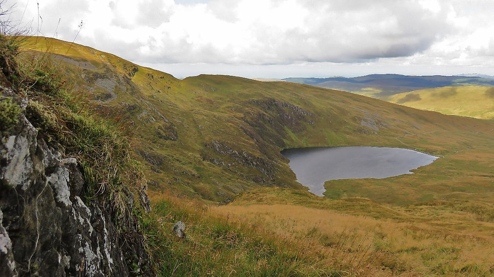
Looking down into Llyn Llygad at 500 metres - Plynlimons reservoir.
Looking down into Llyn Llygad at 500 metres - Plynlimons reservoir.
5 Arrow Trail
Location: Radnor Forest Mid Wales
Rated Difficulty: Medium
View Value: Exceptional
Parking: Good
Public Transport: Available
The Arrow Trail' leads you to the super enchanting river Arrow source an eventual left bank tributary of the Wye. It starts off nice and easy as you walk from the road onto the Gwaunceste hill range in Mid Wales near to the border of Herefordshire. It's laid out before you as the track leads the way onto Gwaunceste hill and the source. Enjoy the ascent as 360-degree views open up revealing Powys and Mid Wales, the Black Mountains and the counties of Shropshire, Worcestershire and Herefordshire. It's a great day out.

Looking towards Hay Bluff in the Black Mountains near the source of the Arrow.
Looking towards Hay Bluff in the Black Mountains near the source of the Arrow.
6 Lugg Trail
Location: Radnor Forest Pool Hill
Rated Difficulty: Medium
View Value: Exceptional
Parking: Reasonable
Transport: None
The Lugg Source Trail starts with a steep, 2km track. Look back for great views of Radnor Forest in the distance. Soon, you’ll reach 400 meters and head toward the source, crossing remote heather moorland home to Curlew, Golden Plover, Grouse, and Lapwing. To the North stands the impressive Beacon Hill with its rocky outcrops. On Pool Hill, the pool that gives it its name leads to the source and the spectacular ravine where the Lugg flows before reaching open country.

The very upper reaches of the River Lugg, where a long ravine reveals its character.
The very upper reaches of the River Lugg, where a long ravine reveals its character.
7 Monnow & Cefn Hill Trail
Location: Cefn Hill Herefordshire
Rated Difficulty: Medium
View Value: Exceptional
Parking: Reasonable
Transport: Bus 3 MIles from Trailhead
Starting on Cefn Hill (486m) in Herefordshire, the Monnow Source Walk explores the source of the River Monnow, one of the River Wye’s principal tributaries. Rising on Cefn Hill, the river flows south-east for 42 miles (68km) before joining the Wye at Monmouth. The hill offers the best views across the Monnow Valley and the eastern escarpment of the Black Mountains. This nature-rich landscape supports rare wildlife and is home to the remains of Craswall Priory, a historically significant Grandmontine priory dating from the early 13th century.

The very upper reaches of the River Lugg, where a long ravine reveals its character.
The very upper reaches of the River Lugg, where a long ravine reveals its character.