


Wye Summits
Explore The Tops
The highest mountain in the whole Wye Basin is Pumlumon Fawr or Plynlimon at 752 meters, which is also the highest peak in Mid Wales. There are 4 other peaks over 700 meters in the catchment. They are Pen Pumlumon Arwystli (741 meters), Pen Pumlumon Llygad Bychan (727 meters), Rhos Dirion (713 meters) and the Black Mountain at (703 meters). These are classed as mountains. There are many more Hewitts or big looming hills over 610 meters 2,000 feet and here we take a brief look at them. If on mobile view a small number are missing.
Key
Pen Pumlumon Fawr 752 Meters (Cambrian) Pen Pumlumon Arwystli 741 Meters (Cambrian) Pen Pumlumon Llygad Bychan 724 Meters (Cambrian)
Rhos Dirion 713 Meters (Black Mt's) Black Mountain 703 Meters (Black Mt's)
Twyn Talycefn 702 Meters (Black Mt's) Pen Lluest Y Carn 699 Meters (Cambrian) Twmpa 690 Meters (Black Mt's) Y Garn 684 Meters (Cambrian)
Chawarel Y Fan 679 Meters (Black Mt's) Hay Bluff 677 Meters (Black Mt's)
Great Rhos 660 Meters (Radnor Forest) Black Mixen 650 Meters (Radnor Forest) Drygarn Fawr 645 Meters (Cambrian) Black Hill 640 Meters (Black Mt's)
Black Mountain South 637 Meters (Black Mt's) Gorllwyn 613 Meters (Cambrian)
Mynydd Troed 609 Meters (Black Mt's West) Y Garmrhiw 604 Meters (Cambrian)

Pen Pumlumon Fawr
Pen Pumlumon Fawr SN 78971 86945 is the highest peak in the Cambrian Mountains Mid Wales at 752 Meters 2,467 Ft. It's a huge massif that's made up of five other peaks hence it's name pumlumon, which means five in Welsh. It's the source of the 3 great rivers the Wye, Severn and Rheidol. Although upland farming and its impacts are evident the uplands are characterized by heathland, blanket bog, acid grassland and oligotrophic lakes. On Pumlumons North Western slope is a huge Cwm or Corrie called Llyn Lygad - worth exploring. The views from the top on a good day are spectacular, which is appreciated by day hikers as well as trail heads on the Cambrian Way that passes over the summit. For more go to Source Walks.
Pen Pumlumon Arwystli
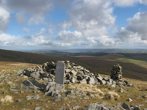
One of the massif's peaks in the Pumlumon range that's within the Wye basin is Pen Pumlumon Arwystli SN 81495 87755. With its gully's and channels on its Southern slopes it directly feeds the source of the Wye (see picture looking South). It is in fact the second highest summit in the range at 741 meters 2,431 feet and is part of the Cambrian Mountains lying within the county of Ceredigion Wales. Britain's longest river the Severn is to the North of the summit. Nearby is Pen Pumlumon Llygad-bychan at 724 meters. Views from this summit include The Upper Wye, Great Rhos in the Radnor Forest, Drygarn Fawr Cambrian Mountains South and Snowdonia to the North.


Pen Pumlumon Llygad Bychan
Above the Cwm or Corrie of Llyn Lygad is Pen Pumlumon Llygad Bychan 724 meters 2,375 feet SN802874. Marked by a Cairn the summit forms the peak of a whaleback ridge leading from the summit of Pen Pumlumon Fawr seen in the picture. As a subsidiary summit and the third highest in the massif it's not got any bells and whistles but like it's grander parent it has some historical interest and magnificent views of Great Rhos in the Radnor Forest, Drygarn Fawr further South, the fantastic Aran Fawddwy and Snowdonia. Directly South 300 meters is the Wye source. The summit of Gamrhiw SN 94401 61189 stands at 604 meters 1,981 Ft just beyond that magical 600 meter contour. It's the last of the 600 meter plus tops in the Wye basin and is situated on the Eastern fringe of the huge Abergwesyn Common a place steeped in history and wildness in the Cambrian Mountains. From here you can stand in the footsteps of the ancients amid a ring cairn, which was not so much a burial site moreover a monumental one. A remote spot it offers something different to the other high tops in the area; a walk down to the Wye Valley at Llanwrthwl via the Y Gamrhiw ridge. Definitely worth exploring.
Photo by: Nigel Brown Geograph.org.uk
“The Raven Doing Acrobatics Above The Mountain Lets You Know How Good It Really Is.”
Mark Jickells

“The Mountains Are Calling & I Must Go.”
John Muir
Rhos Dirion
The Black Mountains are a real gem and there on its North Western slopes is Rhos Dirion 713 meters 2,339 feet a mountain SO 211333 made up of red sandstone that affords the walker great views of the Central Brecon Beacons and the Wye Valley. It feeds the Wye via the Felindre Brook, which then flows into the Llynfi just prior to the Wye at Glasbury. It's a subsidiary summit of Waun Fach the highest peak in the Black Mountains at 811 meters 2,660 feet. From the summit you are able to access other summits within the basin such as Twmpa and Hay Bluff and walk South the Chwarel Y Fan ridge, which feeds the Wye via the Honddu. It's a magnificent area.


Black Mountain
Directly North East of Rhos Dirion or South East of Hay Bluff in the Black Mountains is the Black Mountain (Twyn Llech) 703 meters 2,306 feet the 5th highest peak in the Wye Basin SO 255350. It's in fact a whaleback ridge that's part of the Offa's Dyke path and the Hatterall ridge that forms the border between Powys and Monmouthshire and Herefordshire in England. To the West is the Vale of Ewyas and the river Honddu source and to the East is the enchanting Olchon Valley and the Black Hill the 13th highest peak in the Wye catchment. The peak and ridge is full of highlights with great views of Herefordshire, Twmpa, Waun Fach (see right) and the mountains interior all the way.
Twyn Talycefn
We like whale back ridges - they're exposed, broad and make no grand statement as such. But they do posses a presence all of their own as does Twyn Talycefn 702 Meters 2,303 Ft in the Black Mountains wales - a subsidiary summit of Wayn Fach and an offshoot of Rhos Dirion 1 KM East at SO 22223236. With its great display of cotton grass amid the bog there are views towards Waun Fach and across to the Hatterrall Ridge and Black Mountain to the East. With its Easterly flanks feeding the Honddu, the Monnow then the Wye it adds new perspective on the whole Black Mountains range. It's Southerly slopes feed the great river Usk via Grwynne Fawr. This is a mountain that shares its waters with two fantastic rivers.
Photo by: Jonathan Billinger Geograph.org.uk

“Anywhere Is Within Walking
Distance.”

“The Hill Looked Hard At First
But I Got Over It.”
Pen Lluest Y Carn
Another subsidiary summit of Pen Pumlumon Fawr the summit of Pen Lluest Y Carn 699 meters 2,293 feet lies just South of the Wye source SN 801865 and is an interesting part of the massif with a round burial Cairn on top probably dating to the Bronze Age (c. 2300 - 800 BC). Down below are yet more remains this time from a plane crash a Lockheed F5E 44-24229, which crashed 11 September 1945 killing the pilot Second Lieutenant Xenophon Eugenedes. Below this is the source of the river Tarennig. The summit offers up great views of the Tarennig valley where the remains of the Plynlimon led mine can be found. See Chris Bonington Trail in Source Walks.
Photo by: Chris Andrews Geograph.org.uk
Twmpa
At the Southern end of Hay Bluff is Twmpa 690 meters 2,263 feet or Lord Herefords Knob as it's otherwise known. Right at the top of the Black Mountains Northwest Escarpment SO 224350 Twmpa juts out beckoning a walk to its summit where some of the best views of the Central Brecon Beacons and the Wye Valley can be seen. Made famous by Half Man Half Biscuit's Lord Herefords Knob (awesome track check it out) it lies 4 miles South of Hay On Wye and approximately 2 miles west of Herefordshire in England. Down below the Gospel Pass gives access to the spectacular Vale of Ewyas made famous by the American Werewolf in London. There artist Eric Gill lived not far away at the old Capel Y Ffin monastery.


Y Garn
2 KM South of Pen Pumlumon Fawr is Y Garn (uh-gan) at 684 meters 2,244 Feet. The fourth highest peak SN 775851 in the Pumlumon massif and the 8th in the Wye Basin overall it's summit is marked by a large shelter hollowed out from an ancient burial cairn dating to the Bronze Age. Bordering the Northern edges of the Dyll Faen plantation (pronounced Dyll Vine) there are great views of Pumlumon, Great Rhos in the Radnor Forest, Drygarn Fawr, Aran Fawddwy and down below Nant-y-moch Reservoir, which lye's in the county of Ceredigion. The walk up is fairly straight forward if you set off West from Eisteddfa Gurig the start point of the Chris Bonington Trail.
“The Mountain Of Youth
Is Hiking.”

“Come Hill Or High Water
We'll Keep Hiking.”
Chwarel Y Fan
At the heart of the Black Mountains Chwarel Y Fan SO 25819 29417 stands at 679 meters 2,227 Ft. Extending along the ridge South Eastwards from Rhos Dirion and Twyn Talycefn it's flanked either side by Usk and Wye catchment in the form of the Grwyne Fawr valley where the Grwyne Fawr reservoir resides and the the river Honddu home to Llanthony Priory in the Vale if Ewyas. To the North is Twmpa as seen in the picture. Nearby is the Mynydd Du forest, the wonky church of Cwmyoy and Partrishow Churches dating back to medieval times. Even if you're not religous these places, alongside Llanthony Priory, are worth a visit as you reflect back on your ridge walk.
Photo by: Gareth James Geograph.org.uk


Hay Bluff
Hay Bluff SO 244366 is an iconic peak to walk. At 677 meters 2,221 Ft it's the 9th highest big top in the Wye Basin. As part of the Black Mountains Northern Scarp it feeds the Wye via a myriad of brooks and rivers namely the Esgyrn Brook, Digedi Brook, river Monnow and the river Honddu. The walk up can be steep depending on your approach. The way up via the Off'as Dyke path for example is gentler than from the car park down below. From the top you can see the Wye valley and the Wye coming in from the Cambrian Mountains of Mid Wales, Herefordshire, Cefn Hill, the Radnor Forest, the Begwns and the central Brecon Beacons as well as Twmpa 2KM south. Down below is a stone circle nearby the car park and the Twyn Y Beddau ancient Round Barrow.
Great Rhos
Walking the tops of the Radnor Forest in Powys Wales are for those who like it a tad rugged and wild and without to many people. Great Rhos SO 182639 is the highest point in the range at 660 meters 2,165 Ft, which feeds the Wye via the Black and Mithil Brooks that eventually join the Ithon and Arrow. It's a huge expanse of open moor land on the western side of the Radnor Forest. With great views of the surrounding area of Mid Wales and with the magnificent Harley Valley/dingle down below to the East it's an invigorating space. Nearby is the Mynydd Ffoesidoes nature reserve and the Water Breaks It's Neck waterfall. For those who are into history there are many round barrows on the summits in the area.

“Get High Underfoot.”

“If You Need Me You'll Find Me
In The Mountains.”

Black Mixen
Just South of the Mynydd Ffoesidoes nature reserve in the Radnor Forest Powys Wales is the Black Mixen SO 196644 another bleak top with a broad expanse of moorland. Accompanying the trig point at 650 meters 2,132 Ft is an ancient earthen mound known as a sepulchral mound. It's just one ancient feature amid many in the Radnor Forest, which is juxtaposed to the modern radio communications tower nearby that belongs to the Powys and Dyfed Police Authority. Almost surrounding the top itself is the massive Radnor Forest forest plantation. Most views are unimpeded.
Photo by: Philip Halling Geograph.org.uk
Drygarn Fawr
At 645 meters 2,116 Ft the summit of Drygarn Fawr SN 862584 645 has probably the mightiest ancient summit cairn known to hill baggers in the UK. Situated in the middle of the largest continuous expanse of moorland anywhere in Britain south of the Scottish highlands the high top drains away into the distance lending meaning to a vacuumous space. It isn't empty of course because on a good day the views of Pumlumon to the North and the Central Brecon Beacons to the South are spectacular let alone Mid Wales and the Midlands to the East. You can approach the top from multiple angles either from the Afon Gwesyn in the Abergwesyn Common or the Elan Valley. Either way it's a brillaint meander amid the bog of the aswesome Wye Basin.
Photo by: Trevor Littlewood Geograph.org.uk


Black Hill
Cryb Y Garth SO 274348 The Black Hill or Cats Back is the highest peak in Herefordshire and the highest in England South of Yorkshire at 640 meters 2,100 Ft. Situated on the Eastern fringe of the Black Mountains not far from the Offa's Dyke path and the Hatterrall Ridge, it's characterized by it's long ridge that's peppered with crags and wind blown trees. To the East are views of Herefordshire, Shropshire, Worcestershire and Gloucestershire. Below its Western slopes is the incredible Olchon Valley that feeds the Wye via the Olchon Brook and the Monnow, which starts a few Kilometers North. The Olchon has a mystical atmosphere and with its micro-climate the valley appears lush and fertile. The Black Hill and Olchon loop walk back to the car park is time well spent in this tucked away part of Herefordshire. Bruce Chatwin named his book On The Black Hill after the peak. Featuring twins Lewis and Benjamin Jones it chronicles life in the area.
“You’re off to Great Places! Today is your day! Your mountain is waiting, so… get on your way!”
Dr Seuss

“Don't Worry About How High
Just Head Up.”
Black Mountain South
South of the Black Mountain is Black Mountain South. On the Offa's Dyke Path in the Black Mountains it stands at 637 meters 2089 Ft. Situated at SO 266322 on the Hatterrall Ridge in addition it towers above Capel Y Ffin where the tiny Owl like chapel resides. The Hatterrall Ridge is 10 miles long and runs to the East of the incredible Vale of Ewyas and West of the enchanting Olchon Valley. To the South of Black Mountain South is the Black Darren an ancient landslip that's left behind a giant gash in the mountain side. Further South from here is the Hatterrall Hill itself, which offers views of the Sugar Loaf and Skirrid Fawr. You have to keep an eye out for Black Mountain South because you can miss it as the whole ridge blends in. But because it's another promontory in the Wye basin that's above 600 meters it's worth keeping an eye out for.
Photo by: Mark Jickells


Gorllwyn
A subsidiary summit of Drygarn Fawr, Gorllwyn SN 91795 59052 stands at 613 meters 2,011 Ft. Situated in the vast expanse of what's known as the 'desert of Wales,' in the heart of the Cambrian Mountains it typifies upland savanna. Forming a plateau the summit features a number of disturbed Cairns (see picture) and a substantial shelter cairn. The approach is boggy in wet conditions but not to arduous. For 360 degree views this summit scores high. The Elan Valley is North, the Radnor Forest is to the East with the Black Mountains further South East. The Central Brecon Beacons are directly South.
Photo by: Michael Graham Geograph.org.uk
Mynydd Troed
Lying on the Western Edge of the Black Mountains SO 165292 at a height of 609 meters 1,998 feet is Mynydd Troed, which actually translates as foot because of how it appears from Allt Mawr a few KM South. A steep climb not many consider it within the Wye basin but its Westerly and Northerly slopes drain into Llangorse lake and the river Llynfi before the Wye at Glasbury. It shares the rest with the Usk. With views of the Black mountains to the East and the central Brecon Beacons to the South West you'll also see, to the West of Mynydd Llangorse down below, the spectacle of Llangorse Lake the largest natural lake in South Wales. Mynydd Llangorse and Mynydd Troed form an 8 KM ridge from North to South with a mountain pass at its Northerly tip, which serves as a great spot to pull in and kick back or walk up quickly if driving.


Y Gamrhiw
The summit of Gamrhiw SN 94401 61189 stands at 604 meters 1,981 Ft just beyond that magical 600 meter contour. It's the last of the 600 meter plus tops in the Wye basin and is situated on the Eastern fringe of the huge Abergwesyn Common a place steeped in history and wildness in the Cambrian Mountains. From here you can stand in the footsteps of the ancients amid a ring cairn, which was not so much a burial site moreover a monumental one. A remote spot it offers something different to the other high tops in the area; a walk down to the Wye Valley at Llanwrthwl via the Y Gamrhiw ridge. Definitely worth exploring.
Photo by: Dave Kirk Geograph.org.uk