top of page
Wye Source.JPG

Wye Source Gully Trail

Source

Explore

The off piste 'Wye Source Gully Trail' is exactly that off piste through the Wye gully or cwm to the top where the actual source of the Wye resides sleepily as hikers pass by overhead. Beware this day out is not for those who enjoy manicured paths. If however you enjoy fast running water and cascades, deep gullies and your views to open up after a scramble and a bog bash then this will see you smiling like a Cheshire cat. It's a great trail, which will need a good few hours of your time. 

source walks, source walk, wye explorer, River wye, wye valley, upper wye valley, plynlimon, pumlumon wales, walking plynlimon wales, backpacking plynlimon, exploring plynlimon wales, backpacking mid wales, mid wales backpacking, sweet lamb estate, sweet lamb wales, walking mid wales, plynlymon fawr, walking plynlimon fawr, mid wales, walkning in the cambrian mountains, cambrian mountains, backpacking the cambrian mountains,
river wye viewing, mountain rock, rocky platform, crag, vista, plynlimon view, river wye view, source walks, source walk, wye explorer, River wye, wye valley, upper wye valley, plynlimon, pumlumon wales, walking plynlimon wales, backpacking plynlimon, exploring plynlimon wales, backpacking mid wales, mid wales backpacking, sweet lamb estate, sweet lamb wales, walking mid wales, plynlymon fawr, walking plynlimon fawr, mid wales, walkning in the cambrian mountains, cambrian mountains, backpacking the cambrian mountains,
river wye view, rocky stream, rocky river, vista, plynlimon view, river wye view, source walks, source walk, wye explorer, River wye, wye valley, upper wye valley, plynlimon, pumlumon wales, walking plynlimon wales, backpacking plynlimon, exploring plynlimon wales, backpacking mid wales, mid wales backpacking, sweet lamb estate, sweet lamb wales, walking mid wales, plynlymon fawr, walking plynlimon fawr, mid wales, walkning in the cambrian mountains, cambrian mountains, backpacking the cambrian mountains,

Section 1

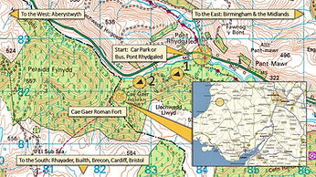
Starting at Pont Rhydgaled (Car park & X47 Bus stop if requested) cross the road into the 'Sweet Lamb Estate' following the same route as the 'Wye View Trail.' From the viewing point drop down to the Wye. This is through some deep acid grass a signature in parts to this wild Wye hike. Once at the Wye, which will take you about 10-12 minutes from the Wye view point head straight up and follow the Wye. 

Section 2

From the bend in the river you quickly head into the Wye gully and Cwm, which starts to feel remoter from the outset. You'll hit patches of bog and by this time you'll be glad we didn't suggest the route in from the concrete water gauging system. We've done it and we reckon that dropping down from the view point is far less hassle and possibly quicker. You can take the left hand sloping bank up or the right. Both are good.

Section 3

This part of Plynlimon or Pumlumon (meaning 5 peaks in Welsh) was, as with Nant Lago, once mined and there are shafts to look out for. In the main though it's a rocky landscape as you head upwards with peat hags in evidence to. These are prime carbon storage systems the kind the plynlimon project are seeking to restore. Near the top choose the furthest away right hand gully. With a steep ascent this will take you to the source, which is no bigger than a bowler hat.

Section 4

There are numerous routes back. You could head for the summit of Plynlimon by heading South along the plateau passed 'Llyn Llygad' on your right but if you're seeking a circular without that then we recommend you head South or left along the fence line just above the source. Check the map - this will take you over 'Pen Lluest Y Carn' all the way to a track. Follow the track through open access land and skirt 'Cripiau Eisteddfa Gurig' East for 2KM until you come to a marked right of way/trail , which leads down to the base of 'Esgair Y Maen' where 'Nant Colwyn' has gathered some volume. At the track here head right or East to the ford across the Wye. From here it's a turn right following the Wye for 'Pont Rhydgaled' on the track you came in on.


Spec N Stats

Start: Pont Rhydgaled    Climbing: 384 Meters    Distance: 9.5 Mile    Time: 4.5 Hours  Walking Grade: 4 

Summary

The Wye gully is fairly easy to get to with well laid out tracks all the way until you have to drop down from the view point (see Wye View Trail). The whole gully up is wild, undulating, boggy and rocky and as you might expect a water world. It is also characterized by sheep farming and pheasant shoots and by the Rally GB tracks once again on your return. However, the Wye source and Plynlimon reveals itself to be remote despite all of this as it offers up views and open space akin to vast swathes of moor. We've said 5 hours from 'Pont Rhydgaled' as we took into account the difficult terrain off piste. All in all a great afternoon or morning out. 

Some Links

River Wye. Click. Britains 5th longest river and most uniterrupted. 

Plynlimon Project. Click. A project to restore Plynlimon.

Cambrian Mountains Society. Click. All things Cambrian Mountains.

Hydrological Study. Click. Plynlimon water catchment.

Plynlimon Led Mine. Click. Industrial history. 

Cool short hiking video in the upper Wye. Click to enter video.

  • YouTube

Map 1: Location/Start

off piste gully trail, source walks, source walk, wye explorer, river wye, wye valley, upper wye valley, Maps, Plynlimon map, river wye map, wye map, adventure map, best map, cambrian mountains map, mountain map, walking map, plynlimon, pumlumon wales, walking plynlimon wales, backpacking plynlimon, exploring plynlimon wales, backpacking mid wales, mid wales backpacking, sweet lamb estate, sweet lamb wales, walking mid wales, plynlymon fawr, walking plynlimon fawr, mid wales, walkning in the cambrian mountains, cambrian mountains, backpacking the cambrian mountains, River bidno, river bidno wales, river flowing, flowing river, beautiful river valley, river valley in wales, river in wales, river hiking, hiking a river, river walks, walking a river, upper wye valley, wye valley, backpacking mid wales, cambrian mountains backpacking, backpacking the cambrian mountains, walking in the cambrian mountains, valley walking, mid wales, mid wales hiking, hiking in mid wales,

Map 3: Return

off piste gully trail, source walks, source walk, wye explorer, river wye, wye valley, upper wye valley, Maps, Plynlimon map, river wye map, wye map, adventure map, best map, cambrian mountains map, mountain map, walking map, plynlimon, pumlumon wales, walking plynlimon wales, backpacking plynlimon, exploring plynlimon wales, backpacking mid wales, mid wales backpacking, sweet lamb estate, sweet lamb wales, walking mid wales, plynlymon fawr, walking plynlimon fawr, mid wales, walkning in the cambrian mountains, cambrian mountains, backpacking the cambrian mountains, River bidno, river bidno wales, river flowing, flowing river, beautiful river valley, river valley in wales, river in wales, river hiking, hiking a river, river walks, walking a river, upper wye valley, wye valley, backpacking mid wales, cambrian mountains backpacking, backpacking the cambrian mountains, walking in the cambrian mountains, valley walking, mid wales, mid wales hiking, hiking in mid wales,

Map 2: Mid Section

off piste gully trail, source walks, source walk, wye explorer, river wye, wye valley, upper wye valley, Maps, Plynlimon map, river wye map, wye map, adventure map, best map, cambrian mountains map, mountain map, walking map, plynlimon, pumlumon wales, walking plynlimon wales, backpacking plynlimon, exploring plynlimon wales, backpacking mid wales, mid wales backpacking, sweet lamb estate, sweet lamb wales, walking mid wales, plynlymon fawr, walking plynlimon fawr, mid wales, walkning in the cambrian mountains, cambrian mountains, backpacking the cambrian mountains, River bidno, river bidno wales, river flowing, flowing river, beautiful river valley, river valley in wales, river in wales, river hiking, hiking a river, river walks, walking a river, upper wye valley, wye valley, backpacking mid wales, cambrian mountains backpacking, backpacking the cambrian mountains, walking in the cambrian mountains, valley walking, mid wales, mid wales hiking, hiking in mid wales,

Map 4: Finish

off piste gullt trail, source walks, source walk, wye explorer, river wye, wye valley, upper wye valley, Maps, Plynlimon map, river wye map, wye map, adventure map, best map, cambrian mountains map, mountain map, walking map, plynlimon, pumlumon wales, walking plynlimon wales, backpacking plynlimon, exploring plynlimon wales, backpacking mid wales, mid wales backpacking, sweet lamb estate, sweet lamb wales, walking mid wales, plynlymon fawr, walking plynlimon fawr, mid wales, walkning in the cambrian mountains, cambrian mountains, backpacking the cambrian mountains, River bidno, river bidno wales, river flowing, flowing river, beautiful river valley, river valley in wales, river in wales, river hiking, hiking a river, river walks, walking a river, upper wye valley, wye valley, backpacking mid wales, cambrian mountains backpacking, backpacking the cambrian mountains, walking in the cambrian mountains, valley walking, mid wales, mid wales hiking, hiking in mid wales,

Route Map-Download

Elevation Profiler

To operate use your mouse as you would on google maps. Press and hold right and move the map around in any direction. For the elevation profiler click mountain icon below left and follow the trail profile with your mouse, which will correlate with the map as you go. To zoom in or out see plus/minus on the right. To return back to just satellite view click mountain icon again. 

Grid Ref & Links

View Platform Grid Ref: SN819861

Source Grid Ref: SN 80174 87168

Track Home Grid Ref: SN803858

For OS Explore 214 Click

For OS Explorer 213 Click 

For The OS Explorer App Click

For GPS Navigation Click

Respect Sweet Lamb, the Wye & Plynlimon.

river wye viewing, mountain vista, plynlimon view, river wye view, river wye source view, punlumon wales view, plynlimon wales view, source walks, source walk, wye explorer, River wye, wye valley, upper wye valley, plynlimon, pumlumon wales, walking plynlimon wales, backpacking plynlimon, exploring plynlimon wales, backpacking mid wales, mid wales backpacking, sweet lamb estate, sweet lamb wales, walking mid wales, plynlymon fawr, walking plynlimon fawr, mid wales, walkning in the cambrian mountains, cambrian mountains, backpacking the cambrian mountains,
source walks, walking the source of a river, wye source, river wye viewing, river wye view, river wye source view, plynlimon wales, river source, source of the river wye, robert gibbings, coming down the wye, source walk, wye explorer, River wye, wye valley, upper wye valley, plynlimon, pumlumon wales, walking plynlimon wales, backpacking plynlimon, exploring plynlimon wales, backpacking mid wales, mid wales backpacking, sweet lamb estate, sweet lamb wales, walking mid wales, plynlymon fawr, walking plynlimon fawr, mid wales, walkning in the cambrian mountains, cambrian mountains, backpacking the cambrian mountains,

Source of the Wye: 'No Bigger than a Bowler Hat.' 

Robert Gibbings

Things to Look Out For

There are a number of things to look out for as you head on up to the Wye source. Check out the many cascades as you ascend and listen to where you are. This is a water world and the Wye eventually becomes the fourth largest river in volume in England discharging 2, 500 million cubic meters of water a year into the Severn Estuary. Notice the sand stone, the boulders (possibly glacial) and the heather. Looking East as you come over the top of Pen Lluest Y Carn you'll see a good portion of mid Wales and there down below also the Wye Valley with the Wye flowing towards Llangurig.

source walks, walking the source of a river, wye source, river wye viewing, river wye view, river wye source view, plynlimon wales, river source, source of the river wye, robert gibbings, coming down the wye, source walk, wye explorer, River wye, wye valley, upper wye valley, plynlimon, pumlumon wales, walking plynlimon wales, backpacking plynlimon, exploring plynlimon wales, backpacking mid wales, mid wales backpacking, sweet lamb estate, sweet lamb wales, walking mid wales, plynlymon fawr, walking plynlimon fawr, mid wales, walkning in the cambrian mountains, cambrian mountains, backpacking the cambrian mountains, rocky river, river rocks, boulder, river boulder, boulders river, flowing wye, river wye flow, upper wye,

Some Peaks

Pumlumon Fawr 752 Meters

Pen Lluest Y Carn 699 Meters

Pen Pumlumon Arwystli 741 Meters

Cripiau Eisteddfa Fach 540 Meters

Cerrig Yr Wyn 550 Meters

Y Drum 462 Meters

Llechwedd Hergoed 535 Meters

Other Points Of Interest

Cae Gaer Roman Fort


There are some good walks close by using the . Pont Rhydgaled car parking area with an X47 bus stop (just ask). Something missed by many is the roman fort called Cae Gaer. You can't see much but once you become aware (check out google for an aerial view) it fascinates to stand in its midst. The river that flows adjacent to it is the river Tarennig a river Wye tributary (see diary). We recommend the walk - the back end there feels remote and wild and if you fancy it you can trek on through to the Nant Syddion Bothy from there or Nant Rhys - check the Mountains Bothy Association out for details.   

source walks, wye explorer, river wye, wye valley, upper wye valley, Cae Gaer, Cae Gaer Roman Fort Wales, Maps, Plynlimon map, roman britain, british roman history, roman map, roman fort map, roman history, adventure map, best map, cambrian mountains map, walking map, backpacking plynlimon, exploring plynlimon wales, backpacking mid wales, mid wales backpacking, sweet lamb estate, sweet lamb wales, walking mid wales, plynlymon fawr, mid wales, walkning in the cambrian mountains, cambrian mountains, backpacking the cambrian mountains, River bidno, river bidno wales, river flowing, flowing river, beautiful river valley, river valley in wales, river in wales, river hiking, hiking a river, river walks, walking a river, upper wye valley, wye valley, backpacking mid wales, mid wales backpacking, cambrian mountains backpacking, backpacking the cambrian mountains, walking in the cambrian mountains, hafron forest, valley walking, mid wales, mid wales hiking, hiking in mid wales,

Route Map-Download

Members of the Mountain Bothies Association

Fort Grid Ref: SN 82369 81941

Nant Syddion Grid Ref: SN773790

Nant Rhys Grid Ref: SN836792

mba_logo.png

Book


As we're viewing the Wye source here we'd like to mention the excellent book 'Coming Down the Wye' by Robert Gibbings. We recommend the read. It's a 1940's classic that chronicles the time Robert Gibbings spent in the upper Wye during the 40's. This is old school. 

Check this visit and video out at the cottage he stayed at

to write the book. There's a reading from the book also.

  • YouTube

The Bidno Valley


The Bidno Valley, which plays host to the river Bidno another Wye tributary is a beautiful hidden gem a short distance East from the Wye View platform. From the Sweet Lamb estate it's rough going but there is public access to the valley and river from near Llangurig. We recommend the rough route in from East to West as a boggy wild traverse. However, not everyone is up for that so here is the much easier going Llangurig Route. We assume that if you're considering the Wild way you can find your way. 

source walks, source walk, wye explorer, river wye, wye valley, upper wye valley, Maps, river wye map, wye map, adventure map, best map, cambrian mountains map, mountain map, walking map, walking plynlimon wales, backpacking plynlimon, exploring plynlimon wales, backpacking mid wales, mid wales backpacking, sweet lamb estate, sweet lamb wales, walking mid wales, plynlymon fawr, mid wales, walking in the cambrian mountains, cambrian mountains, backpacking the cambrian mountains, River bidno, river bidno wales, bidno river, bidno valley, flowing river, beautiful river valley, river valley in wales, river in wales, river hiking, hiking a river, river walks, walking a river, upper wye valley, backpacking mid wales, mid wales backpacking, cambrian mountains backpacking, backpacking the cambrian mountains, walking in the cambrian mountains, hafron forest, mid wales, mid wales hiking, hiking in mid wales,

Route Map-Download

River bidno, river bidno wales, river flowing, flowing river, beautiful river valley, river valley in wales, river in wales, river hiking, hiking a river, river walks, walking a river, upper wye valley, wye valley, backpacking mid wales, mid wales backpacking, cambrian mountains backpacking, backpacking the cambrian mountains, walking in the cambrian mountains, hafron forest, valley walking, mid wales, mid wales hiking, hiking in mid wales, geograph, geograph photo, photo geograph,

Trails Nearby


There are a few renowned trails in the area. The Wye Valley Walk is the most obvious. We recommend this having walked it ourselves. It passes through Wales and England and back into Wales and follows the course of the beautiful river Wye. (See the River Wye Diary) or the Wye Valley Walk Partnership for details. 

Other trails include the Cambrian Way said to be the mountain connoisseurs trail. If you like mountains and like it wild then this trail is for you. It passes right by the Wye source and through Plynlimon.  

Finally there's Glyndwrs Way sections of which we've done. It celebrates the life of the Welsh independence fighter Owain Glyndwr and skirts Plynlimon passing through the Hafron Forest and then good parts of the Wye Basin Namely the upper reaches of the Ithon and within yards of the river Lugg source in the Radnor Forest. (see river Ithon & river Lugg Diaries).

Llangurig


Llangurig the highest village in Wales gets its name from St Curig a Celtic Roman Catholic bishop and saint of Wales during post Roman times. With only 700 plus residents it's a handy little place. Look out for some refreshments at the Blue Bell Inn & the Black Lion. There's also the village tea room and post office where you can pick up some supplies if you're backpacking. We've used it for that purpose and it's super useful in the remote upper Wye. For more information see the Llangurig Village website.

bottom of page