


The Monks Trod
Llwybr Y Mynaich
Explore
Somewhere between the ruins of Abbey Cwm Hir and Strata Florida, medieval monks once crossed the heart of Mid Wales. Exactly where they walked, however, is another matter.
The Monks Trod or Llwybr Y Minaich (Hu Bira Minike) isn't an official, waymarked trail. It's a route pieced together from historical research, surviving tracks and the landscape itself. In the Cambrian Mountains there is more evidence to work with, but east of them the trail becomes much harder to follow. Above St Harmon, on Cwm Hir Bank, one medieval track survives. Beyond that, you're largely working things out for yourself.
And that's what makes this walk such an adventure.
From Abbey Cwm Hir, I chose to stay high on Cwm Hir Bank rather than drop down to St Harmon. The views alone made it worthwhile. Further west, the route becomes more confusing as you pick your way through fields around the base of Moel Hywel, with one blocked path adding to the uncertainty. Here, paying attention to the landscape matters as much as following a map.
Then you reach Gilfach and everything changes.
The Marteg Valley opens out towards the Wye, with the Cambrian Mountains rising beyond in a huge, rugged sweep. It feels like you're being drawn into the mountains themselves.
The two abbeys give the Monks Trod its story, but the landscape is what makes the walk. This is a route through a part of Mid Wales that feels remarkably undiscovered, where old tracks have faded, the way ahead isn't always obvious and you have to use your judgement to cross the country.
It's not a walk where everything is laid out for you. And that's exactly why it's worth doing.

Waymarking is nonexistent, making for an adventurous trail.

The ruins of Abbeycwmhir and Home Farm Campsite.

The end of the trail at the entrance to Strata Florida or Ystrad Fflur, meaning flat bottom and flower.
Waymarking is nonexistent, making for an adventurous trail.
The Monks Trod
-
Distance: 42 km.
-
Start/Finish: Abbeycwmhir Visitor Centre
-
Total ascent: 1,192 M.
-
Duration: 2.5 days.
-
Walking Grade 3.5.
-
Terrain: Lanes, Woodland Paths, Open grassland, bog, hillside tracks, valleys, some steep sections.
-
Views: Abbeycwmhir forest, Radnor Forest, Marteg Valley/Gilfach, Mid Wales interior, Wye Valley, Elan Valley, Cambrian Mountains Interior.
-
Highlights: Valleys, deep cwm's, Claerddu Bothy, history, River Wye, River Elan/Valley.
-
Best time to walk: Spring, summer or autumn.
Getting to the start
If travelling by public transport, allow time for the journey into Abbey Cwmhir itself. From Llanddewi Ystradenny it is approximately 6.5 km on foot, so an overnight stay and taxi to the Visitor Centre may make for a much better start to the walk. See below for more details or you could just order a taxi from Newtown or LLandrindod Wells.
The busses:
-
From Hereford: Sargeants Brothers Bus, 461 Hereford to LLandrindod Wells. Once there, catch the LLndrindod Wells to Newton, T4 bus. It's fairly regular. Get off at Llanddewi Ystradenny, after St David's Church.
-
From Cardiff/Brecon: X4 Cardiff to Merthyr Tydfil and then, as above, the T4 from Merthyr straight through to Llanrdindod Wells. Stay on for Newton, getting off. at Llanddewi Ystradenny, after St David's Church.
-
From Shrewsbury: The X48 from Shrewsbury to LLandridnod Wells. For Builth, see the T4
-
From Newton: The T4 to Llanddewi Ystradenny, nr Ithon View.
-
From Aberystwyth: The X75 from Aberystwyth to Llangurig. Then the X47 From Llangurig to LLandrindod Wells. From there it's the T4 for Newtown getting off at Llanddewi Ystradenny, after St David's Church.
In LLandindod Wells, there are several taxi services to take you to Abbeycwmhir if that's what you want to do to save the 6.5 KM walk to the start (See here for the OS route). Likewise Newtown is well served, too.
Getting under way: You can crack on upon arrival and try your luck at finding a wild camp (see potential spots below) or camp the night next to the abbey on the property of Home Farm and start in the morning. Arrange the camp through them.
Places to stay in LLandindod Wells and Newtown
We'll recommend the one we've stayed in, although there are many more. During a stormy night on the Wye Valley Walk we stayed in the Llanelwedd Arms Hotel on the left bank of the Wye. It's a good stay - recommended. Also The Firs on the right side of the Wye, a little bit out of town. For others, click here.
For Newtown check out booking.com.
To make it clear/Repeat. Staying overnight is advised because the hike in to the trail head is about 6 miles. So, it's about getting an reasonable start.
The Return Trip From Strata Florida
The return trip from Strata Florida is fairly simple but it involves numerous bus Journies, which, to be are pleasant. .The journey includes:
Camping in Pontrhydfendigaid
This is a 2KM walk down a quiet lane. For the camp Nantyrhelyg is recommended. The facilities weren't overly clean when I camped there, but the owner is a friendly chap. The grass was neat and cut.
3 Bus Journey's back to Llandrindod Wells or 2 to Newtown. They are:
-
Pontrhydfendigaid to Aberystwyth on the T21 - two busses - one in the morning and the other in the early afternoon.
-
Newtown. Aberystwyth X75 (Stand 3) to Newtown.
-
LLandrindod Wells. Aberystwyth X75 to LLangurig - change at LLangurig on the X47 for LLlandrindod Wells.
-
Hereford. LLandrindod Wells - Sargeants Brothers 461 - to Hereford.
-
South, Cardiff. LLandrindod Wells, Builth Wells, Brecon, Merthyr, Cardiff. T4 to Merthyr. X4 Merthyr to Cardiff.
The journey back will take you through the Cambrian Mountains and past the source of the Wye. It's a dramatic and beautiful bus ride. You can take your time and mooch around Aberystwyth if you fancy. A cuppa tea or food at Weatherspoons in the train station is convenient as it is next to the bus terminals.
Supplies/Refreshment
If you need emergency outdoor supplies and you've made it to Newton or LLandrindod Wells, then try any number of stores. They're reasonably sized towns. Aldi is right opposite the bus station in Llandrindod Wells, and in Newton Aldi and Tesco are a few streets away. Each town is served by numerous cafe's and places to eat.
Rations Main Meal Tip
For a rations main meal tip on trail try Couscous, Chorizo, organic dried onion and 1.5 tablespoons of Pumpkin Seed Powder for more protein. When camping it's important to keep chores to a minimum. For example, you don't want to be heating food up and then spending an age cleaning your mug from remains clinging to the bottom. Couscous is easy - just add water. Re: the Chorizo being cured meat it keeps and Pumpkin Seed Powder is fairly tasteless. For additional taste to your already flavoured Couscous/Chorizo add spices or a hot sauce. Enjoy, rinse your pot with a tiny bit of water (drink it afterwards) and relax.
For other camping tips click here.
The ruins of Abbeycwmhir and the campsite if camping.

The small yet informative Abbeycwmhir Exhibition.

Llywelyn ap Gruffudd Memorial, a nice slab of slate.
The ruins of Abbeycwmhir and the campsite if camping.
History, The Route & Landscape
Standing at the start, you're under no illusion that you are in a valley the Cistercians revered. It's why they built Abbey Cwmhir where they did. How the abbey came into being is expressed clearly at the visitor centre, but briefly, the Cistercian community was first established here in 1143 and refounded on the present site in 1176.
The abbey became an important centre of Welsh religious and political life and is perhaps best remembered as the traditional burial place of Llywelyn ap Gruffudd, the last native Prince of Wales, following his death at Cilmeri in 1282. Little remains of the great abbey today, but its ruins and surrounding valley give a strong sense of the remote landscape the monks chose — and the landscape you are about to cross.
What would the monks have seen?
As you leave the abbey and approach Cwm-hir Bank through the modern commercial forest, this is perhaps the most intriguing question to ask:
Was the forest here in the monks' time? And if so, what did it look like?
The answer is almost certainly very different from the landscape you see today.
The plantation forest is a relatively modern feature. The monks would not have been walking through ranks of spruce, larch and other commercial conifers. Yet that does not mean that these hillsides were bare. Quite the opposite. Wherever woodland survived on the lower and more sheltered slopes, it would probably have been predominantly broadleaf woodland, with sessile oak likely to have been one of its most characteristic trees.
Imagine approaching Cwm-hir Bank beneath a more open canopy of oak and birch, with hazel, rowan and holly amongst the undergrowth. In wetter ground, alder and willow would have favoured the streams and flushes. Yew could occur locally, as could juniper on poorer, more exposed ground.
We cannot say that the exact trees beneath today's plantation stood here eight hundred years ago. But there is good local evidence for the importance of woodland and oak around Cwmhir. The abbey possessed substantial deer parks — the Great Park and Little Park — immediately north of the valley, and parts of their medieval boundary banks can still be traced beneath the modern forestry plantation. Later descriptions of the estate speak of hillsides that had once been covered with oak forest, while some ancient oaks still survive within the former parkland.
So as you walk through the trees today, it is worth looking beyond the plantation itself. The forest may be modern, but the landscape beneath it has a much older story.
And then there is the Monks' Trod itself.
As you approach Cwm-hir Bank, you are coming towards one of the surviving sections of this remarkable medieval route. The road climbs and zig-zags down the bank before continuing towards Park Farm and across the ridge of Moel Hywel. Archaeological investigation has shown that substantial sections of the Trod survive as deliberately engineered, terraced roadways, in places using a remarkable medieval 'cut and fill' construction.
The valley, looking west, would have looked very different in the medieval period

The Victorian bridge near St Mary's Virgin church.

The magnificent valley of Abbeycwmhir with the Radnor Forest beyond.
The valley, looking west, would have looked very different in the medieval period
From woodland to open hills
As you leave the woodland behind and climb towards the open country around Moel Hywel, the landscape begins to feel much more familiar.
Here the difference between medieval and modern scenery may have been surprisingly small.
The higher hills were never likely to have carried continuous woodland. Exposure, altitude, wet ground and centuries of grazing all favoured an open landscape of grass, heather, rushes, bracken and bog, with occasional scrub and scattered trees in more sheltered places. The great expanses of open hill that you see today therefore have much deeper roots than the modern forestry landscape.
And people had been crossing these hills for thousands of years before the Cistercians arrived.
As you descend and contour around Moel Hywel, look towards Camlo Hill and the surrounding ridges. The landscape contains traces of prehistoric activity, including a Bronze Age standing stone and nearby cairn. There is also a possible cairn on a rocky ridge just north of the summit of Camlo Hill, positioned in a place with commanding views along the Cwmhir valley. Its archaeological interpretation is uncertain, but its location is evocative: long before the monks crossed these hills, people were already looking out across this country, travelling through it and leaving small traces of their presence.
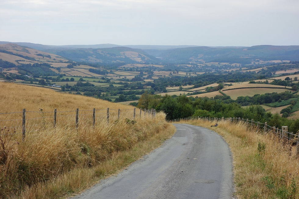
Looking west towards Cabon Coch in the Cambrian Mountains. Moel Hywel is on the right, out of the picture.

Contouring around Moel Hywel from a distance. It stands at 505 Meters.

Landscape shot of the Marteg and Wye Valley, with Moelfryn in the front, Gamallt to the left, and Yr Wylorn on the right.
Looking west towards Cabon Coch in the Cambrian Mountains. Moel Hywel is on the right, out of the picture.
Down to Gilfach and the Wye
From the open hills the Monks' Trod begins its descent towards Gilfach Nature Reserve, the River Marteg and the Wye. The character of the walk changes noticeably here. The high, exposed country gives way to steep-sided valleys, woodland, pasture and rushing water — a landscape strongly shaped by the last Ice Age.
Gilfach is a wonderful place to pause and consider just how long people have been using this landscape. The reserve was once a working hill farm and is now managed for its wildlife, but its history reaches back thousands of years. A Bronze Age burial cairn is evidence of people here around 3,000 years ago, while later routes through the valley were used by Roman soldiers, medieval travellers and, eventually, the railway.
The Gilfach Longhouse, now restored and forming part of the reserve's historic farmyard, is a particularly evocative survival. Dating from the 16th century, it was a simple Welsh longhouse: people lived at one end while livestock were sheltered at the other. The Radnorshire Wildlife Trust rescued the old farm in 1988 and has since restored the longhouse and buildings and conserved the surrounding landscape.
Below, the River Marteg meets the Wye. Water has always been central to this landscape — not merely as scenery, but as a route through otherwise difficult country. The Marteg and Wye valleys provided natural corridors through the mountains, linking the uplands with the wider valleys and settlements.
For a brief moment, the quiet of the valley can also be interrupted by a ghost of a very different age: the railway. The old Mid-Wales Railway once followed the valleys here, crossing the Marteg and negotiating the difficult country around Gamallt. Where the monks travelled on foot or horseback, Victorian engineers brought railways, bridges and steam locomotives into the same landscape.
And yet, beneath all these layers, the shape of the country is older still. The steep valleys and rounded hills are part of a landscape whose form was profoundly influenced by glacial processes during the Ice Ages.

Looking down into the Wye Valley from the base of Moelfryn.

The Wye Valley, looking south from the top of Llofftyddgleision. Rhayader is in the distance.

Looking south over Craig Goch. The Elan flows through here.
Looking down into the Wye Valley from the base of Moelfryn.
Into the Cambrian Mountains
Crossing the Wye and beginning the climb again, the route enters the Cambrian Mountains. Above the Wye at Moelfryn, another fragment of the old farming landscape survives in the name and remains of Lluest Pen Rhiw. A lluest was a shepherd's dwelling or station on the upland pastures; such places can have origins in the medieval hafod tradition of seasonal mountain settlement, which this station represents. It's a fascinating relic.
This is a useful reminder that the apparently empty hills were never truly empty. For centuries they were working landscapes — grazed, crossed and managed by farmers and shepherds.
Ahead, the views open towards the Elan Valley.
Today the reservoirs dominate the landscape, but they are remarkably recent. The great dams and reservoirs were constructed between the 1890s and the early twentieth century to provide Birmingham with clean water. The first phase dramatically transformed the valley, flooding farms and altering the river landscape; Claerwen followed in the mid-20th century.
Before the reservoirs, however, the River Elan was itself one of the defining features of the landscape. Rivers and valleys were natural lines of movement across the mountains, and the archaeological record shows that people had been using this country for thousands of years. Mesolithic flint tools have been found in the Elan, while later prehistoric cairns, settlements and other monuments are scattered across the uplands.
There is even a Roman presence here. Esgair Perfedd, above the Elan, preserves the remains of a Roman marching camp thought to date from the AD 70s, probably associated with the Roman conquest of Wales.
So when you look across the reservoirs towards the high country, it is worth remembering that this is not an untouched wilderness. The water may be Victorian, but the routes through the mountains — and the human use of them — are vastly older.

The start of the path above Craig Goch, looking east. LLuest Cwmbach Bothy is in front.

North east over the top of Glanhirin with LLan Fraith beyond.

Looking southwest over the Afon Claerwen, with Dibyn Ddu in the distance.
The start of the path above Craig Goch, looking east. LLuest Cwmbach Bothy is in front.
The Trod across the mountains
Somewhere here the Monks' Trod or 'Llwybr Y Mynaich' makes its own quiet statement about the age of the landscape.
You have already followed the path from Cwmhir. In places on Cwm Hir Bank it remains: a deliberately engineered track. But beyond the Elan it becomes more pronounced in the mountains — a path constructed by cutting into the slope and building up the lower side — the medieval cut and fill technique. Its route links the two great Cistercian houses of Abbey Cwmhir and Strata Florida across the tops and through the folds of the Cambrians.
The route here is a landscape of open mountain, sheep pasture, bog and stream. By the time you reach the Claerddu Du Bothy near the Teifi Pools, the mood has changed once more. The old sheep-farming landscape becomes the dominant theme.
For centuries these mountains have been shaped by livestock and by the people who moved with them. The Cistercians themselves were deeply involved in sheep farming and the management of upland estates. The Elan landscape preserves evidence of medieval granges, fields and routes associated with this pastoral economy, while the surrounding uplands continued to be used for grazing long after the monasteries disappeared.
The mountains have been worked for centuries.
From the bothy and the high country beyond, the route continues towards the Teifi Pools, across another ancient upland landscape, before eventually descending through Nant Egnant towards Strata Florida.
By now the journey has taken you through woodland, river valley, prehistoric landscape, Roman country, medieval farming country, Victorian engineering and centuries of sheep farming.
And beneath it all, the same old mountains remain.

The trail to the Claerddu Bothy.

Early morning outside Claerddu Bothy. Built in 1852, the brook has kingfishers; the marsh has owls, and wrens are present.

Inside the Nave at Strata Florida/Ystrad Fflur.
The trail to the Claerddu Bothy.
Strata Florida
And finally, Strata Florida — Ystrad Fflur, the Vale of Flowers.
After crossing the mountains from Cwmhir, the arrival at the abbey feels like the natural conclusion to the Monks' Trod. The first Cistercian community arrived here from Whitland in 1164, settling initially at Hen Fynachlog. In 1184, under the patronage of Rhys ap Gruffudd, the Lord Rhys, the abbey was established on its present site beside the Teifi.
Strata Florida became far more than a monastery. It was a centre of Welsh political and cultural life, closely associated with the princes of Deheubarth. In 1238, Llywelyn ap Iorwerth summoned the Welsh princes here to recognise his son Dafydd as his successor. The abbey also became an important centre for the recording of Welsh history and literature, associated with the Brut y Tywysogion — the Chronicle of the Princes — and some of the great manuscripts of medieval Wales.
Its church and monastic buildings were once magnificent. Today, the great west doorway, fragments of decorated medieval floor tiles and the surviving foundations give only a glimpse of what stood here. Generations of Welsh princes were buried at Strata Florida, while the great poet Dafydd ap Gwilym is traditionally said to lie beneath a yew in the churchyard.
But perhaps the most fitting thing about arriving here on foot is that the landscape still makes sense of the monastery.
The monks came to a remote but fertile valley, with water, pasture and access to a huge upland estate. Sheep farming became central to the abbey's economy, and its influence extended across a network of farms and granges. The same mountains and valleys you have crossed were part of the working landscape that sustained the monastery.
The abbey was dissolved in 1539 and much of it subsequently fell into ruin. Yet Strata Florida never entirely disappeared. Its ruins, its churchyard, its surrounding farms and its association with Welsh princes, poets and the landscape of the Teifi have preserved something of its extraordinary place in Welsh history.
And so the Monks' Trod ends where it began in spirit: with a Cistercian house set within the landscape it helped to shape.
You have crossed a country of ancient hills, rivers, prehistoric monuments, Roman routes, medieval farms, sheep walks and monastic roads.
The mountains were here before the monks.
But the monks left their mark.
Summary
This is a walk where preparation matters. The Monks' Trod crosses remote country with long stretches between settlements and limited opportunities to resupply. Water can be unreliable, while conditions underfoot range from good tracks to rough, boggy ground. Weather can change quickly on the open hills, so good navigation and appropriate clothing are essential.
The rewards, however, are considerable. From Abbey Cwmhir, the route follows a surviving medieval trail through woodland and open upland, descending to Gilfach, the Marteg and Wye before climbing into the Cambrian Mountains and Elan country. Along the way are prehistoric remains, Roman traces, old farming settlements, sheep country and the remarkable engineering of the Elan reservoirs.
This is also a deeply photographic walk, with constantly changing landscapes from wooded valleys to wide mountain horizons. Look beyond the path and the landscape reveals layer upon layer of human history.
Ultimately, the Monks' Trod is best approached as both a challenging upland walk and a journey through time — following in the footsteps of the Cistercians across a landscape that people had travelled and shaped for thousands of years.
Video on YouTube: The Monks Trod Short
A few moments from the trail — the landscape, weather, tracks and places that make the Monks' Trod what it is.
The Monks Trod Feature Length Part 1 & 2
Quick OS Map Preview

For the Most Detailed Guide Download OS Mapping GPX, compatible with most platforms-Kamoot, Outdooractive or All Trails.
For OS Link Click, here.
The GPX file can also be used with a variety of dedicated GPS devices and outdoor watches — including models from Garmin, TwoNav, Suunto and Coros — as well as smartphone navigation apps that support GPX route import.
Click For Interactive OS Profiler

For the full interactive map with pins and locations click the image below. More information on the Way is available - History, water sources etc.

Paper Maps/Click Maps for Links to Shop


Map Reading
You need to know where you are at all times. There are no sign posts for the Monks Trod, which makes it interesting. A tip would be to orientate as much as you can, which is a staple in map reading. Also take note of the micro features - particularly crossing the central part of the Cambrian Mountains. As you walk Clawdd-du-Bach (Grid Ref: SN 85884 69892), for example, look out for the Esgair Cormwg ridge to your right or north if heading west - also Glamhirin Farm in the valley below/north. Prior to stepping onto the Clawddu-du-Bach the visible trails get confusing - you can lose them and end up veering off south west. By bearing in mind the Esgair Cormwg and handrailing it you should keep to the route at this point.
Water Sources
There's no resupply on the Epynt plateau, no village shop or town. The importance of staying hydrated cannot be underestimated. I did the way in May 2025, which coincided with a heatwave. The tops are exposed with no shelter and I was roasting. Up until this point I had no real problem obtaining water with a filter. However, for reasons unknown my filter was lost near the end of the trail - it was in a side pouch - accessible. But I still needed water. I took a risk out of one of the streams. Days later, you guessed it, I had stomach ache. There are sheep galore in these valleys and all use the streams. So filter, filter, filter or boil, boil, boil.
So where are the main watering holes? To see view locations see the interactive map.
For gear related to filtering water click here.

For this spring, head for the Lost Arc venue. It's situated to the side of the wall on your right, near the venue. Good water.

This source supplied by a borehole is fine - tested. It's on the Wye Valley Walk before Gilfach.

This is luxury in the Clairddu bothy. A spring-fed source emptying into a Belfast sink. Lovely - refill to your hearts content.
For this spring, head for the Lost Arc venue. It's situated to the side of the wall on your right, near the venue. Good water.
Camping, Wild Camping & Bothy
The Monks Trod doesn't cater for wild camping. Because of this there's virtually no official camp sites. The only sanctioned camp sites are at the start and finish. They are:
Home Farm, Abbeycwmhir/Start. After contacting Home Farm where the exhibition is located camp anywhere amid the ruins. It's an interesting camp and lovely ruins. Althoguh it's not a camp site as such they do have a small outbuilding with a loo, washbasin and shower and there’s a tap in the field. For Home Farm, contact: Mr Hamer, 01597 851666 or contact on site when you arrive.
There are no stores in the village although the Happy Union pub is open a few times a week.
Nantyrhelyg in Pontrhydfendigaid Village, 2KM West of Strata Florida/Finish. After contacting the small holding Nantyrhelyg, pitch anywhere on their site. It's a pleasant enough site with a reasonable view and stream running through. Although the grass is cut short the wash facilities and surrounding sheds are not so clean, or at least they weren't upon our stay. But it works at £11.50 per tent. If you don't fancy it you could possibly pitch at the far end of the village playing fields. Your bus - the T21 to Aberystwyth - will be in the morning.
The village has a local store and two pubs the Red Lion (a real pit) and the Black Lion, a Café now.
Other Camping on Trail
As with any wild camp on trail you just have to use your imagination and be respectful in the process. Day 1 will get you to Gilfach Nature Reserve or the Wye Valley. In fact, physically fit, it will get you beyond these two locations onto the tops of Moelfryn. Here there are some pitches. 5 miles on - a 15 mile day from Abbeycwmhir - is the Elan valley. You could camp beside the Elan or trek 2 miles south to the LLuest Cwmbach Bothy.
But camping sites are plentiful if you think outside of the box and stealthily. Another example just prior to the Wye Valley if you had a late start at Abbeycwnhir would be the Gilfach Welcome Centre near the Wye.
You wouldn't think twice ordinarily but when push comes to shove you can spot a bivvy. What sold this as a bivvy idea? It is a ready made shelter, in the week it is fairly quiet and if you bivvy down late the odds are you'll see nobody.
So, if you use your head and look around you can find plenty of good pitches. However, bare this in mind. Be respectful and leave no trace.
For advice on Wild Camping and Gear ETC click here.
Wild Life
At the Clairddu Bothy whilst contemplating beside the Afon Claerddu surprisingly a Kingfisher emerged. And in the large marsh beside the Bothy a Short-eared Owl hunted on the wing or at least that's what was favoured at a distance. Other species spotted on trail were the European Golden Plover, which was exciting. Red Kites further east from the Bothy near Abbeycwmhir & Gilfach were prevalent in the sky.

Our own photo of a Short-eared Owl, taken from the Radnor Forest in Mid Wales. They favour remote uplands and wetlands.
Our own photo of a Short-eared Owl, taken from the Radnor Forest in Mid Wales. They favour remote uplands and wetlands.
Wild Life Continued...
It can be said that the Cambrian Mountains - being so inhospitable to development has had a positive impact on the wildlife in the area. With the mountains being so remote it has had plenty of time to find its rhythm. Besides Short-eared Owls and Brown Hare there are many more that make the Cambrians home from Red Squirrels, which exist in the woodland margins to the south of the trail. There are other mammals, too, from Pole Cats through to Pine Marten and mountain Hares, which have been observed in the area.
Crossing the Elan the loss of spawning Atlantic Salmon were contemplated - a great loss to pump water to Birmingham as the dams prevent the cycle. But in the Elan beyond Craig Goch there are Brown Trout (Salmo trutta) and the aquatic fauna is heavily dominated by insects. These range from Mayflies (Ephemeroptera), Stoneflies (Plecoptera) and Caddisflies (Trichoptera) all good for Trout.
A closer look at birds. Besides the Curlew there are:
-
Cuckoo in the valleys
-
Skylark, the sound of the open hills
-
Redstart
-
Snipe, found in wetter mash areas
-
Stonechat
-
Red Kite, Buzzard, Merlin, Goshawk, Peregrine Falcon and Sparrowhawk
-
Feild Fare and Redwing, winter migrants
Fungi & Flora is extensive and is known globally as a stronghold for nutrient-poor grassland fungi. Look out for:
-
Waxcaps: Over 20 colorful varieties can be found here, including pink, red, yellow, and purple waxcaps.
-
Fairy Club Fungi
-
Earth Tongues
-
Flora: Yellow flag irises (in boggy areas), heather, and bilberry.
To explore more visit the Cambrian Society website. Click, Here.
Other Trails in the Area
With the Cambrian Mountains, Mid Wales and Wye Valley you'd expect some good trails and for Long-distance trails there are. They are:
-
Wye Valley Walk. This 136 mile trail start either on the slopes of Plynlimon or Chepstow and traces the length of the River Wye, Britain's Fifth longest river and passes the Epynt to the east of its boundary.
-
The Cambrian Way is a fantastic yet demanding long-distance trail stretching 298 miles (479 km) along the mountainous spine of Wales. Often described as the "Mountain Connoisseur's Walk," the route begins at Cardiff Castle in the south and finishes at Conwy Castle in the north.
-
The Teifi Trail The Teifi Valley Trail is an 83-mile (134 km) long-distance walking route in west Wales that follows the River Teifi from its Teifi Pools source to the sea. The source is not far from the Claerddu Bothy and Llyn Egnant, which it passes - the same route as the Monks Trod in this part of the mountains. Recommended.
Lastly, and this is not a hike, there is the Trans Cambrian Way a long-distance cycle route, which intersects the Monks Trod and stops at the Claerddu Bothy given your timing. It's an epic 100 miles through Mid Wales and the Cambrians. Worth doing.
Last Reminder
As this is not an officially marked trail you will need to be able to map read proficiently. If you can't it's not advised and especially not in poor weather because on top it is remote and you could be wondering for hours if you have veered off the route.