


Epynt Way
Explore
Passing through a deep cwm in a remote part of Mid Wales, with the sound of your boots, your breathe and the occasional sheep for company, you could be forgiven for thinking you've got the Mynydd Epynt to yourself. Then the crack of gunfire echoes across the hills and you're reminded that the Epynt Way here is no ordinary long-distance trail.
Throughout its 68km, it skirts the edge of the Sennybridge Training Area, one of the largest military training grounds in the UK. It gives the route a gnarly character all of its own. One moment you're wandering through quiet valleys and open moorland, the next you're aware that soldiers are training just beyond the next ridge.
The military presence is only part of the story. In 1940, 200 Welsh-speaking people who lived on Mynydd Epynt were forced to leave their homes so the land could be used for wartime training. More than eighty years later, that history still lingers. As you follow old tracks through forests, across streams and over wide open moorland, it's difficult not to wonder what life was like here before the army arrived.
With far-out views, quiet paths and a feeling of being removed from the modern world, the Epynt Way is a trek for those of you who enjoy discovering the stories behind a landscape as much as the landscape itself. It's a really good one.

Waymarking is plentiful, either as fingerposts or simple marker posts. Great views towards Builth Wells.

Views of the Central Brecon Beacons right out of the blocks. The views keep giving.

Wild camp spots exist throughout. Be respectful and leave no trace. Looking out towards the Cambrian Mountains.
Waymarking is plentiful, either as fingerposts or simple marker posts. Great views towards Builth Wells.
Epynt Way
-
Distance: 68 km
-
Start/Finish: Epynt Visitor Centre or The View Point SN995428
-
Total ascent: 2,154 M
-
Duration: 2-3 days
-
Walking Grade 3.5
-
Terrain: Open grassland, hillside tracks, Woodland Paths, valleys, some steep sections
-
Views: Carmarthen Fans, Brecon Beacons, Cambrian Mountains, Mid Wales, internal valleys
-
Highlights: Valleys, deep cwm's, military presence, history
-
Best time to visit: Spring, summer or Autumn
Getting there
Unless you have someone to drop you off the best way to get to the start and finish is to catch a bus to Builth Wells, which is closest to your start point. Once there, stay overnight or order a taxi (see below). List of busses:
-
From Hereford: Sargeants Brothers Bus, 461 Hereford to LLandrindod Wells. Once there, catch the LLndrindod Wells to Builth Wells, T4 bus. It's fairly regular.
-
From Cardiff/Brecon: X4 Cardiff to Merthyr Tydfil and then, as above, the T4 from Merthyr straight through to Builth Wells.
-
From Shrewsbury: The X48 from Shrewsbury to LLandridnod Wells. For Builth, see the T4
-
From Aberystwyth: The X75 from Aberystwyth to Llangurig. Then the X47 From Llangurig to LLandrindod Wells.
In Builth Wells, there are several taxi services to take you to the Upper Chappel viewpoint off the B4520 or the visitor centre if starting from there, either is accepted. The one we used was Adeys Taxis - very friendly and on time. Tel: 01597 822118. Address: Bridge House, Howey, Llandrindod Wells, LD1 5PT
Places to stay in Builth Wells
We'll recommend the one we've stayed in, although there are many more. During a stormy night on the Wye Valley Walk we stayed in the Llanelwedd Arms Hotel on the left bank of the Wye. It's a good stay - recommended. Also The Firs on the right side of the Wye, a little bit out of town. For others, click here.
Supplies
If you need emergency outdoor supplies and you've made it to Builth Wells, then we recommend the Bug Out, the go-to place for outdoor gear or supplies/rations, etc. It's just on the edge of town.
For general food, check out the towns Contis in the high street, St Mary's Bakery, Co Op.
Rations Main Meal Tip
For a rations main meal tip on trail try Couscous, Chorizo, organic dried onion and 1.5 tablespoons of Pumpkin Seed Powder for more protein. When camping it's important to keep chores to a minimum. For example, you don't want to be heating food up and then spending an age cleaning your mug from remains clinging to the bottom. Coucous is easy - just add water. Re-the Chorizo being cured meat it keeps and Pumpkin Seed Powder is fairly tasteless. For additional taste to your already flavoured Couscous/Chorizo add spices or a hot sauce. Enjoy, rinse your pot with a tiny bit of water (drink it afterwards) and relax.
For other camping tips click here.
History & Landscape
Standing at the start, you're under no illusion that you are on a military training base. How this came into being is expressed clearly at the visitor centre. We mentioned in the introduction to the Epynt Way that the whole area was once Welsh-speaking and populated by farmers. It was steeped in farming tradition until the outbreak of war. Then, as we've already said, the farmers and families were cleared out in 1940 to make way for the training area. It was a heartbreaking separation from the land and the people because many were scattered.
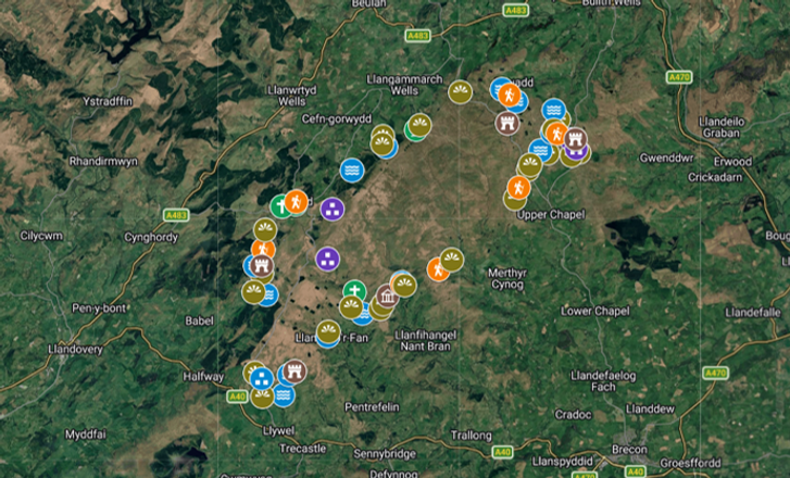
On your Epynt Way look out for farmsteads and interesting places that tell the story of the Epynt. For more locations check out the pinned map below. Meanwhile here are a few locations:
-
World War two storage facility. Note the debris outside the perimeter. There's toilet ceramics etc suggesting a guard house : SO020437
-
World War two prisoner of war camp housing Italian Prisoners of War who were building the concrete road within the range. Spot the outline of the huts/layout: SO017442
-
Tair Tywarchen the old drovers inn built to serve the Welsh drovers moving livestock across the remote mountain passes: SO020442
-
St David's Church in Tirabad, built in 1766. During the 1950’s the village of Tirabad was expanded to accommodate families of foresters who moved in to undertake forestry operations after the clearance. Grid Ref: SN879412
-
Mabioins Way Monument, built by engineers in 1973 to celebrate the construction of the Mabioin Way, the army training area perimeter road. It's a curious monument: SN940448
-
An old farmstead at the head of the valley. This one quietly tells a story. It's likely that the field systems are medieval. The track leading south west away from the farmstead was certainly the only way in. Grid Ref: SN860383.

An early farmstead. Opposite is the remnants of a barn.

The valley looking back towards the farmstead. The only way in. Just south of Cefn Coch.

Some leftovers of someone's military rations. This is poor tactics and admin.
An early farmstead. Opposite is the remnants of a barn.
Summary
This is a walk where preparation matters. Water sources can be unreliable in places (See below), so carrying enough from the start of each section is essential, especially in warmer months. Supplies are limited once you leave Builth Wells, and resupply options are non-existent on the trail itself.
Although the route is well-defined in parts, conditions underfoot can vary from firm tracks to boggy, rough ground, particularly after wet weather. Good navigation skills are useful in poorer visibility, where the open landscape can feel deceptively featureless.
Because of its military use, sections of the route may be affected by live firing, so checking access restrictions before setting out is important.
Despite its challenges, the Epynt Way rewards those who take it on with a real sense of isolation and space. Packing light makes a noticeable difference over multiple days, especially given the undulating terrain and long stretches between settlements. A simple, well-organised kit will make the experience far more enjoyable.
Beyond the practicalities, this is also a deeply photographic walk. From wide Cambrian horizons and empty valleys to shifting light across the hills and the remnants of lost farmsteads, it’s a landscape that constantly invites you to stop and look more closely.
Ultimately, the Epynt Way is best approached as both a hike and a story: one of wild upland walking, quiet immersion, and a landscape marked by both natural beauty and human history.
Video on YouTube: Epynt Way Day 1 of 3
Quick OS Map Preview

For the Most Detailed Guide Download OS Mapping GPX, compatible with most platforms-Kamoot, Outdooractive or All Trails.
For OS Link Click, here.
The GPX file can also be used with a variety of dedicated GPS devices and outdoor watches — including models from Garmin, TwoNav, Suunto and Coros — as well as smartphone navigation apps that support GPX route import.
Click For Interactive OS Profiler

For the full interactive map with pins and locations click the image below. More information on the Way is available - History, water sources etc.
Paper Maps/Click Maps for Links to Shop


Map Reading
A tip for navigation would be not to rely on the sign posting or finger posts, which are marked YELLOW. You need to know where you are at all times. The sign posts do not let you know this. We found that one sign post had been renewed and placed elsewhere (the old one was still in the ground some meters away) and that there were two trails marked with the Epynt Way, one for hikers and the other for pony trekkers the latter of which took us away from the hikers trail as it confusingly joined it. The sign posts are helpful, but read the trail as if they're not there.
Water Sources
There's no resupply on the Epynt plateau, no village shop or town. The importance of staying hydrated cannot be underestimated. I did the way in May 2025, which coincided with a heatwave. The tops are exposed with no shelter and I was roasting. Up until this point I had no real problem obtaining water with a filter. However, for reasons unknown my filter was lost near the end of the trail - it was in a side pouch - accessible. But I still needed water. I took a risk out of one of the streams. Days later, you guessed it, I had stomach ache. There are sheep galore in these valleys and all use the streams. So filter, filter, filter or boil, boil, boil.
So where are the main watering holes? To see view locations see the interactive map.
For gear related to filtering water click here.
Wild Camping
The Epynt Way doesn't really cater for wild camping. Because of this there's virtually no official camp sites. But camping sites are plentiful if you think outside of the box and stealthily. An example, at Grid Ref: SN 92681 44761 would be the top of this long field amid the woodland where a tiny flat spot alongside the fence can be found.
You wouldn't think twice ordinarily but when push comes to shove you can spot a pitch. What sold it? There was forest to the rear, left and right and so the only access for the landowner was from the front, and it was at the top end of the field giving you plenty of space to view any incoming. In addition you would be a speck from afar. The odds were it was going to be a good pitch. On night two a similar choice was made only this time in a tucked away Cwm.
So, if you use your head and look around you can find plenty of good pitches. However, bare this in mind. Camp outside of the military training area boundary or on the very edge of it. And do not spark any fires - be safe and stealthy. And always LEAVE NO TRACE.
For advice on Wild Camping and Gear ETC click here.
Wild Life
Prior to pitching here next to this stream a Heron was perched and flew out the moment it was disturbed. There was another instance near LLandeilo 'r Fan Grid Ref: SN 89357 34689n where a Brown Hare simply loped past within yards as if humans were not an issue. And at the close of the trail in the Upper Chapel Curlews sang clearly and with abandon.
These valleys and Cwms are full of an array of wild life. See the full list below.

A stream on the southern section. If drinking be sure to filter.
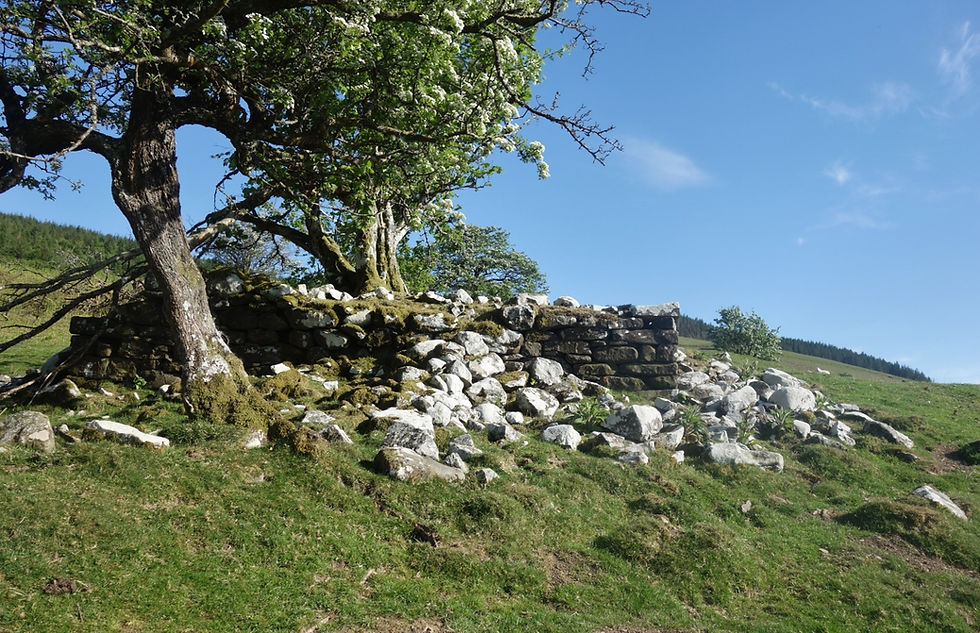
Probably a sheep enclosure now taken over by Hawthorn.

If camping, make your pitch outside of the training area and leave no trace.
A stream on the southern section. If drinking be sure to filter.
Wild Life Continued...
It can be said that the Sennybridge range has had a positive impact on the wildlife in the area. With the military range being of limits much of the time it has had plenty of time to find its rhythm. Besides Heron and Brown Hare there are many more that make the Epynt home from Red Squirrels, which exist in the woodland margins to the east
A local said in discussion that the Dulas flowing through Tirabad plays host to salmon spawning. I knew that some upper tributaries were seeing a resurgence but it was nice to hear this from someone living beside the stream, which flows into the Irfon and then the Wye. The Epynt also sees Polecat, Otters in the streams and rivers running off the Epynt and wild ponies. There are also Roa deer in Crychan and Halfway Forest, which the trail passes through.
Birds are plentiful, too. Besides the Curlew there are:
-
Cuckoo
-
Skylark, the sound of the open hills
-
Redstart
-
Snipe, found in wetter mash areas
-
Stonechat
-
Red Kite, Buzzard, Goshawk, Peregrine Falcon, Sparrowhawk & Short Eared Owl
-
Feild Fare and Redwing, winter migrants
Fungi & Flora is extensive and is known globally as a stronghold for nutrient-poor grassland fungi. Look out for:
-
Waxcaps: Over 20 colorful varieties can be found here, including pink, red, yellow, and purple waxcaps.
-
Fairy Club Fungi
-
Earth Tongues
-
Flora: Yellow flag irises (in boggy areas), heather, and bilberry.
To explore more visit the Epynt Way Visitor Centre. Click, Here.
Other Trails in the Area
Prior With the Central Brecon Beacons nearby and the Cambrian Mountains you'd expect some good trails and for Long-distance trails there are. They are:
-
Wye Valley Walk. This 136 mile trail start either on the slopes of Plynlimon or Chepstow and traces the length of the River Wye, Britain's Fifth longest river and passes the Epynt to the east of its boundary.
-
The Heart of Wales Line Trail is a 141-mile (227 km) long-distance walking route that shadows the scenic 121-mile rural railway stretching between Craven Arms and Llanelli.
-
The Cambrian Way is a fantastic yet demanding long-distance trail stretching 298 miles (479 km) along the mountainous spine of Wales. Often described as the "Mountain Connoisseur's Walk," the route begins at Cardiff Castle in the south and finishes at Conwy Castle in the north.
-
The Beacons Way (Ffordd y Bannau) is a challenging 99-mile (159 km) linear trail crossing Bannau Brycheiniog (Brecon Beacons National Park) in South Wales. It runs east to west from Abergavenny to Llangadog, featuring rugged peaks, glacial lakes, and castles.
Last Reminder
As this is a military training area always stay on the permitted path or trail and do not stray from it. The trail is part of a public rights of way network, but when the military are training and red flags are up they are closed to the public. The range though is what makes this trail a lot of fun.