


Staunton-On-Wye
Brobury, Monnington Loop
Explore
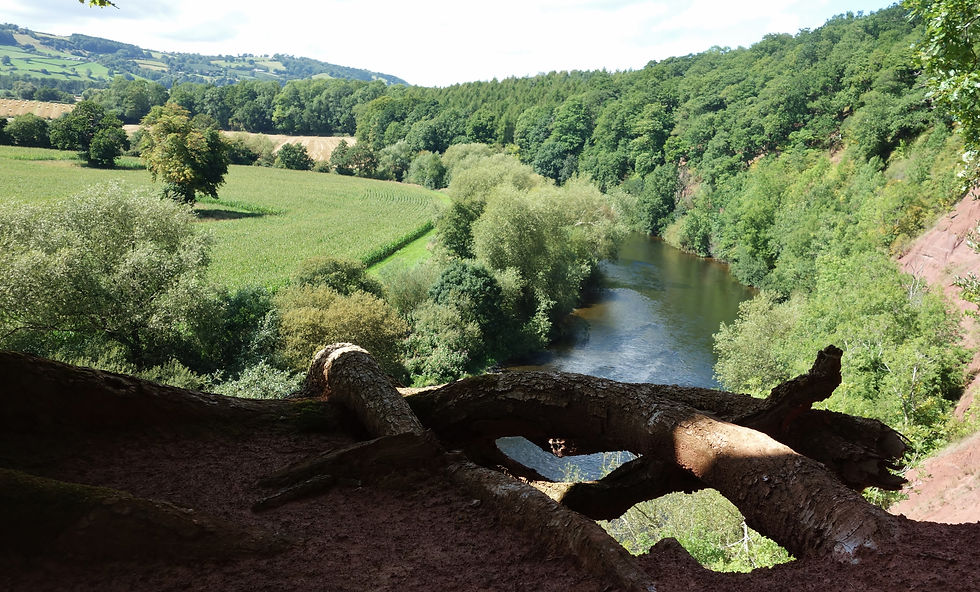
Starting from Staunton-on-Wye Village Hall, this easy-going loop follows a quiet back lane for about a kilometre before crossing the main road at the crossroads. It starts off calm enough, but things shift at Brobury Scar — a sandstone cliff above the River Wye that catches you off guard a bit, bringing in an edgier feel than you’d expect here in Herefordshire.
The route then joins the Monnington Walk, running along a pine-lined estate avenue that for a moment feels almost Scottish in character, before easing towards the medieval Monnington Court. A look at the nearby churches is worth your time, then it’s an easy wander back to the village — proper back country in between, quiet, with very few cars or people about. The New Inn waits at the end if you feel like a pint or a brew.


Staunton-On-Wye, Monngton Loop - Quick Info
-
Distance: 8.5 km
-
Total ascent: 110 m
-
River section: Brief at Brobury Scar
-
Duration: 02:25
-
Walking Grade 1 - Easy
-
Terrain: Back Lanes, Woodland paths, estate Pine avenue
-
Start/Finish: Staunton-On-Wye Village Hall
-
Highlights: Dramatic Brobury Scar View, estate Pine avenue, medieval history
-
Best time to visit: Spring, summer and autumn for scent, sound and colour
Parking Up
There are two cars parks if you include the New Inn pub. The other is the village hall where you can park when there are no events.
Public Transport
Public transport is pretty OK. You'll be catching the No446 from Hereford. It sets off early enough and there are returns for a nice window into the walk.
Walking the Lane to the Cross Roads
Walking the lane down to the crossroads, Staunton-on-Wye sits quietly, a village with roots going back to at least medieval times and likely earlier, first recorded in the Domesday survey and long shaped by farming and river life. Nothing much will rush past you here, and that pace holds as you go.
The crossroads at the A438 is the only place things really pick up, where traffic heads off towards Kington, Hay-on-Wye, and into the surrounding valleys — the Golden Valley, Monnow Valley, and the wider Radnorshire hills beyond. All of them worth getting into if you’ve got the time.
Brobury Scar View Point
You only really see Brobury Scar if you walk or paddle to it. From elsewhere it sits above a tight bend in the Wye, tucked into the line of the river and easy to miss if you’re not moving through the landscape. The sandstone is bright red in places — proper Old Red Sandstone — and the cliff itself is one of the larger inland exposures of its kind in the Anglo-Welsh Basin, if you want the formal description.
The Scar is edged by ancient beech, gnarly sweet chestnut and oak, growing right up to the drop. A short distance away lies Moccas Park, one of the finest collections of ancient oak in the UK, and you can catch glimpses of that wider woodland system from here. It all runs together — river, woodland, and a sense of ground that hasn’t shifted much for a long time.
The Pine Avenue, History & Landscape
The Monnington Walk runs for about a mile as a straight pine avenue between the fields and river, Scots pines lining the route in a way that shifts the feel of the landscape completely. Walking it on the Wye Valley Walk, coming down from the river’s source, it can catch you off guard — for a stretch it feels more like the Scottish Highlands than Herefordshire, a mythic rhythm opens up inside.
It was planted in the 1600s by James Tompkins of Monnington Court, but this doesn't define the experience. What you notice is the scale and the line of it, and the way it pulls you through the landscape to either end depending.
It’s also a place where life is still moving through — passing through some time ago a grass snake appeared, completely unbothered, crossing the avenue. It has to be said moments like this stay with you more than dates although in the 1400's it's said that Owain Glyndwr was buried at Monnington Court.
For the court and church history check this link out.
Eat/Drink & Trails
If you fancy more than just the view, there are a few good spots to grab something to eat or drink around Staunton-On-Wye. The 16th C New Inn at the center of the village is a cool place with easy going décor. There's a restaurant and beer garden. For a coffe or tea/cafe there's Oak Church Farm shop down the road.
Summary
From the start, the lane slows things down and you can just kick back into it. This is Herefordshire and the Wye doing what they often do — looking fairly straightforward at first, then quietly revealing a bit more than expected. By the end, you’re glad you made the time for it. Brobury Scar, the pine avenue, and the history around Monnington all shift the feel of what looks like a simple countryside walk.
Quick OS Map Preview

For the Most Detailed Guide Download OS Mapping GPX, compatible with most platforms-Kamoot, Outdooractive or All Trails.
For OS Link Click, here.
The GPX file can also be used with a variety of dedicated GPS devices and outdoor watches — including models from Garmin, TwoNav, Suunto and Coros — as well as smartphone navigation apps that support GPX route import.
Click For Interactive OS Profiler

Things to Look Out For
There are a number of things to look out for in and around the area. You've already got a fix on the Brobury Scar, the Pine avenue and the historical sites. Across the way next to Moccas Park, that place of ancient oaks, is Moccas chapel. Now this isn't about being religious but these places are fascinating and this one is old - 10th C shortly after the Norman invasion. It still has it's Norman Arch typical of that period. Across the way to the south west is Bredwardine bridge a historic Grade II listed, six-arch red brick bridge over the Wye, built between 1762 and 1764 - it's a nice bridge and a pretty cool place to swim in season. In the village of Bredwardine itself is the burial place of the Reverend Francis Kilvert (1840–1879), famously known as the "walking vicar" and Victorian diarist. The Francis Kilvert diary is a great read. Recommended.

Other Wye Valley Trails
We’re gradually building a full set of walks along the Wye, from the upper reaches down to the lower valley. Besides those in the main Best Wye Routes & Paths menu more routes are being developed — keep an eye out for the next ones to get deep down with.
In the meantime check out the preview of the Hatterrall Ridge, Honddu, LLanthony Valley loop below. It's a classic Black Mountains ridge and valley walk.
For long distance see Wye Basin Long Distance Trails and the Wye Valley Walk.
Other Trails
Across from Staunton-On-Wye towards the Black Mountains is the Offa's Dyke trail as featured in Wye Basin Long Distance trails. It's a 177-mile (285 km) National Trail running along the England-Wales border, connecting Sedbury Cliffs near Chepstow to Prestatyn on the North Wales coast. Definitely worth every step.
In addition there's the Golden Valley Pilgrims Way. This is an interesting 59 mile trail that starts at Hereford Cathedral and loops back around stopping off at significant churches/places of worship where you can bivvi down. Further south there's the Beacons Way and the Cambrian Way - again they're all on the Wye Basin Long Distance Trails page.
Hatterrall Ridge, Honddu, LLanthony Valley
Directly 12 miles south of Staunton-on-Wye is the southern tip of the mighty Hatterrall Ridge. With its highest point standing at just over 700 meters and 9 miles in length the Hatterrall Ridge is a sky walk that's remote in its essence. This walk takes in a portion of the ridge starting at Cwmyoy to the rear of St Martin's Church, 'the most crooked church in Britain.' Although remote on top thousands have walked it either as part of the Offa's Dyke or from the Monnow or Llanthony Valleys either side of the English/Welsh border. Dropping down you handrail the River Honddu a tributary of the Monnow and Wye before passing, at its base, the incredible Darren a huge tear in the land exposing a rock face created during the last ice age. It's a proper mix of upland and valley.

Click OS Map for a preview of the route. OS users can log in. See also GPX download.

Some Local Outdoor Stores
Some outdoors stores in the area are: Rohan and F W Golesworthy & Sons/Hay-On-Wye. Trekkit, Mountain Warehouse, Regatta/Hereford, U-Xplore, Mountain Warehouse Abergavenny, Chrickhowell Adventure